
Networked medieval strongholds in Garhwal Himalaya, India
New publication by Associate Professor Tom Brughmans, Nagendra Singh Rawat, Vinod Nautiyal and Devi Dutt Chauniyal (Hemvati Nandan Bahuguna Garhwal (Central) University, India).
Rawat, N., Brughmans, T., Nautiyal, V., & Chauniyal, D. (2021). “Networked medieval strongholds in Garhwal Himalaya, India”, Antiquity, first view, 1-20. DOI: https://doi.org/10.15184/aqy.2021.4
Associate Professor Tom Brughmans recently published a study of visual signalling networks between medieval forts in Garhwal Himalaya (India) with his colleagues Nagendra Singh Rawat, Vinod Nautiyal and Devi Dutt Chauniyal, in the journal Antiquity.
The work was featured in Nature’s research highlights, which likens the findings with the famous scenes from the Lord of the Rings where Pippin lights the fire beacons of Gondor and Sauron’s eyes survey the landscapes of Mordor. And there’s a good reason for that. The study explores whether the hundreds of forts of hill and mountain tops and ridges identified in the central Himalayan region might have functioned as a visual signalling system (like the fire beacons between Middle-Earth’s Gondor and Rohan).
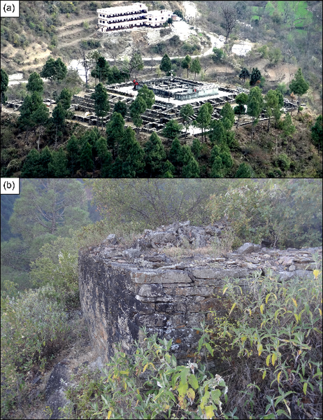
The survey work conducted in the context of Nagendra Singh Rawat’s PhD research identified hundreds of forts and smaller fortified structures for the first time. Why were these located at such prominent high elevations? Sadly, the phenomenon is poorly researched: Only one site was partly excavated and there are only a handful of radiocarbon dates. So we do not know much about the contemporaneity of the forts which hampers many attempts to explain it. The authors realised that despite these big gaps in our archaeological knowledge, they could still formally represent a theory and check whether it is a plausible explanation for the forts’ locations at all.
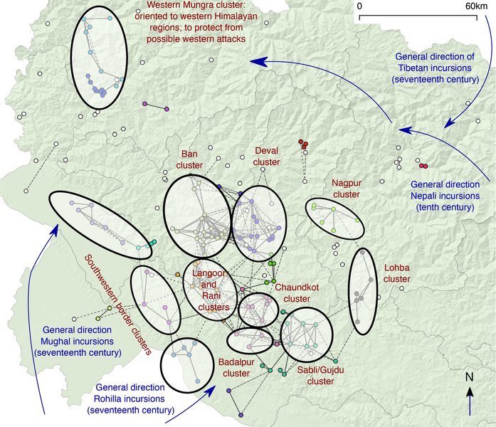
Specifically, they checked whether the forts might have been placed in these prominent spots because of what could be seen from there. Could one fort be seen from another? Could information about enemy aggression be communicated between pairs of forts using smoke or fire signals? (that is where the Middle Earth link comes from: the eye of Sauron visually controlling Mordor, and Pippin lighting the beacon in Gondor). Can we identify clusters of forts that can locally share information effectively? Perhaps these represent administrative units? And could the sites collectively have functioned as a visual signalling system to share information over hundreds of kilometres?
The authors combined GIS and network methods to computationally represent their theory, and confirmed that it is mostly plausible. Moreover, they performed a statistical sensitivity analysis to evaluate the effects the missing chronological information about the forts might have on their results. You can read the full results in Antiquity here.
Abstract from article
Hundreds of high-elevation medieval strongholds are dispersed throughout the Central Himalayan region of Garhwal Himalaya, India. Believed to have originated in the eleventh century AD, these sites are interwoven into local folklore, yet they have been subject to limited research. This article presents new survey data, along with computational and spatial analyses of 193 Garhwal strongholds, facilitating the assessment of more complex hypotheses – particularly visual-signalling theories – concerning the fortification phenomenon. The results strongly suggest the integration of Garhwal's strongholds as a coherent visual-signalling network. In turn, the method also holds great potential for the evaluation of putative visual-signalling networks in other archaeological contexts.